Visitor Count

Friday 22 July 2011

Kayaking: Whitely's to Brown's Landing

I enjoyed my Sunday morning outing so much I determined to go again during the week, as I had three days off work. On Tuesday I did a scouting  mission, checking out various official landing places on the McKenzie and Willamette. Be aware that you can zoom in on any of the picture by clicking on them, and use the back button on your browser to return to this blog.


I found the above map at Taylor Landing, quite a way up the McKenzie. I like its pared-down nature, showing just the major roads, the rivers, and the landings.

In the evening Beth and I prepared for an early start. Beth starts work at 7:30am in the Summer, and she was very kindly giving me a lift to Whitely's Landing on her way to work, so I had an even earlier start to set things up. I drove North to Brown's Landing with my bike on its rack, parked in a prominent spot visible from the river, put the bike rack in the trunk and cycled the 7.5 miles back home before 6:30am. I had estimated 5 miles, but my bike computer told me 7.5. I saw the sun rise twice, once in a gap in the Cascade Mountains, and a second time over the top of them. My legs were pretty tired by the time I got home, but fortunately I wouldn't be using them again for a while. At 6:45 we headed out to Whitely's where Beth dropped me, plus my Kayak and assorted clobber around 7am.


My attempted self portrait before setting out.


Most Landings have this substantial concrete ramp, though Brown's does not as we shall see later. Fortunately my Tuesday scouting had shown me exactly where I could safely land there without wetting a foot.


I'm off! That little wier/rapid caused my worst moment of the day. Not yet ready to paddle after pushing off, the current pushed me sideways into it and I nearly capsized. In fact I grounded and had to push off backwards. paddle backwards some more to get room, and then forwards to shoot the rapid. I'll be ready quicker next time, and not be fooling about with the camera.


Not far on I found a still backwater to explore. Cotton seeds had drifted down to float on the surface, and the lack of current left a glassy surface. The water pressure from the main stream keeps this section full, but without any current, and I saw water boatmen scooting about on the surface.


This fallen tree blocked the way, but I was able to scooch under the end in my kayak. Any larger craft would be stuck unless it could ram over the tree, which is not recommended.


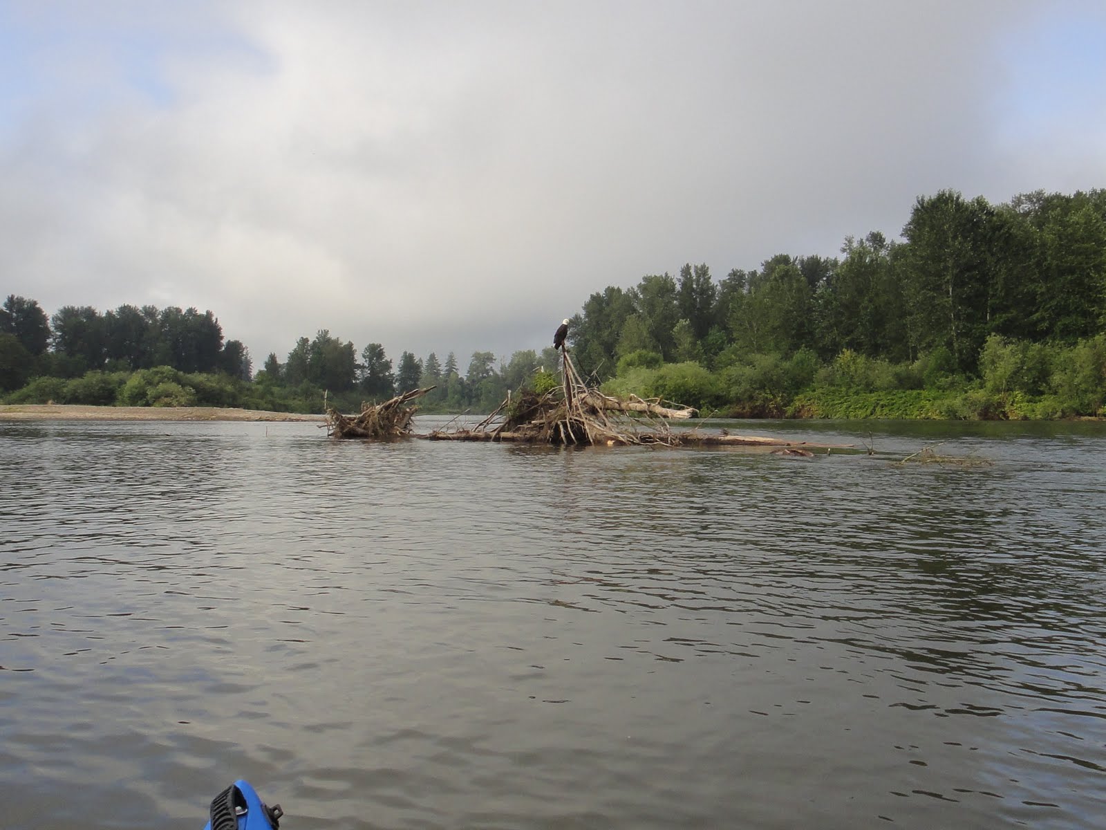
 Heading back downstream, I soon came to the convergence of the McKenzie and Willamette. The McKenzie is just to the right of the gravel spit. The conjoined river widens dramatically, the converging currents causing eddies, backflows, undercurrents, upcurrents and other sorts of fun, though the picture totally fails to convey this.


Along the river from this point on I frequently came across fallen trees that had washed up on the shore. This particular tangle looked quite menacing and I gave it a wide berth, lest I should get washed onto it and skewered or otherwise had my day spoilt. Mostly the trees lay on the gravel shores, parallel to the river, like huge dinosaur bones. A good rise in the water height might lift them and carry them downstream, or they may now be stranded until they rot.


This leaning tree will no doubt be washed out of the bank in the next few years.


Woah. The best moment of the day, by several spade-fulls of bestness. An (American) Bald Eagle, just for me. This picture actually looks upstream, and I'd already passed him and paddled back towards him, just awestruck by his majesty and complete ignorance of some puny blue humanoid. Eventually I got too close and he flew off, but golly gosh, he was big.


Not so majestic, but another oooh moment. A pair of raccoons came waddling down to the bank for a drink and a wash as I floated up to them, trying not to splash or otherwise startle them. By the time I got close enough for a decent picture one had left, and the other was watching me suspiciously, before turning and vanishing into the undergrowth.


More stranded trees.


In the UK Herons will normally be seen singly, as they each stake a claim to a section of river for their hunting, so I was quite surprised to come across four at once. You can see another tipping tree, and just to the left of the patch of grass at the turn of the spit is a bird that turned out to be an Osprey. It took no notice of me, or the herons flying off in herony panic, and continued to munch on the fish it had caught.


Three of the herons landed on this tangle of fallen trees and pretended they hadn't taken fright at nothing. The fourth messed up the pose by flying about in herony panic.


I could be wrong, but I rather think this is an Eagle or Osprey nest at the top of a telegraph pole.


My first sight opf my car from the river, telling my it's time to start steering across to the left.


Reverse perspective, imaging a blue blob on the river as far as you can see, and that's me. The car was parked next to this little tree, and from here you can see that if I fail to make the right choice of stream, I'm going to miss my landing altogether. My course took me across that little rapid between the bank and the island, past the stranded trees, then paddlign mightily back up in the slower current along the bank until I reached a soft muddy bit under a tree.


Here's the soft muddy bit, as scouted on Tuesday. Just right for a kayak, hopeless for anything bigger, and having landed here I needed to drag the kayak up a near-45 degree slope to gain the top of the bank and my car.


Kit laid out to ensure I have everything I started with. Helmet (my bike helmet, just in case of a capsize in rapids), lifevest, main paddle (white blades), emergency paddle in case I lose hold of the main ones (yellow blades), splashdeck (which does keep some water out and warmth in on windy stretches), lunch (half a Subway roll and some trail mix), bottle of Mountain Dew for energy. An old towel is already on the car (to prevent scratches when lifting the kayak), and the mounting straps and rubber wedges too. Nobody was about so I was able to brazenly strip off my wetsuit and climb into dry jeans & t-shirt, though there was a portaloo where I could change if there was a crowd.   


Kayak all mounted, and ready to roll.


My next planned expedition in a couple of weeks' time will take me all the way from Brown's to Corvallis, and looks to be about 8 hours in duration. The most I've done in one day so far is about two hours, so it'll be quite step up. My ever-supportive Beth will act as my support team, seeing me off at Brown's and meeting me in Corvallis for a meal out and ride home.

Monday 18 July 2011

More Kayaking Adventures on the Willamette River

In the last week I've had a couple of outings on the river. I had a day off last Wednesday, so decided to take my kayak to a spot I'd found, right where Beltline Road crosses the Willamette River.


This pebble spit runs under the bridge, and provides parking space for those who wish to access the river. It also creates a natural harbor downstream,  ideal for launching a kayak or other shallow draft boat.


Looking downstream before launching, you can see how clear and calm the water is.


The main stream runs fast under the bridge's central span, but to the left this calmer water offered a possible route upstream. Those big rocks up ahead looked menacing though, and I had to get out and carry the kayak over. The water was only ankle deep.


Just upstream of the rocks, I found I needn't have bothered because the water was flowing much too fast for me to make any more progress. I got in and tried to paddle, but with my weight added the kayak was grounded, and as soon as I got out the water carried the empty kayak back downstream. I could have waded further, but then I'd have had trouble getting into the kayak.


Back in the little lagoon, I found a fellow kayaker. His kayak is a sit-upon style, great for calm water paddling, but not so good for keeping the drips off you. He didn't care, and was just enjoying a quiet paddle around on this blisteringly hot day.


I enjoyed my outing and determined then and there to do a longer trip, with Beth's assistance, on Sunday before an early evening shift. Thus after my Saturday shift was over we loaded the kayak onto Beth's car, ready for an early start on Sunday.


Our cats very considerately woke us at 5:30am, so despite the rain we were able to set out around 7:30am in a two car convoy. The kayak rests on two foam rubber rests, and has four straps to secure it, one to the front, one to the back and two running right over the top and through the inside of the car.


We parked my car next to the river at my planned egress point, in as visible a spot from the water as I could devise. I didn't want to miss it and drift too far downstream.


We then took the kayak on forther upstream to a spot I'd scouted out where I knew I could launch safely. This did require a drag across the grass from the car to the water's edge of a hundred yards or so, but with wet grass and gravity aiding me it wsasn't bad. I am trying to look nonchalent.


Having reached the bank, I had to lower the kayak down about 12 feet using the strap, but this was all part of the plan. The straps and foam rubber rests come with me in the kayak, ready to remount it on my car roof. I also have a spare set of paddles in case I lose hold of my main pair, a helmet on in case I tip over in rocks, and a lifevest over my wetsuit. I cleverly chose a lifevest and wetsuit that matched the color of the kayak, so it looks like I thought about it. I have my car keys, cell phone, and wallet in a waterproof box, and some snacks and drinks in case of hunger or thirst.


The view straight across the river prior to launch. It all looks very calm and innocent. I bade adieu to Beth and took a brief turn upstream, to look at a couple of rapids, or wiers. There are several points along the river where rocks and stones have formed a natural wier across the river, and as I suspected, these bar upstream progress to all but the most determined paddler. I was right to choose to go with the flow.


Turning back downstream, this was my first bridge to negotiate. Most of the bridges are no problem, but after seeing the wier at Beltline I wasn't sure what to expect. This is a roadbridge and carries Interstate 105 and route 126, which are the same road at this point.


Through that bridge and in sight of the next, the rain which had been falling steadily all morning decided to fall a bit steadier. I could not have been better prepared than I was in my wetsuit, with the padding from my lifevest adding extra insulation, though my glasses were useless and I soon zipped them into the pocket of my splashdeck. My eyesight is not so bad that I wasn't able to progress quite happily without them from here on.


My second bridge, this time for bicylists and pedestrians, carries people across to from a park on the West bank to the Valley River Center Shopping Mall on the East bank. Both banks of the river all along this stretch have a cycle and footpath; not some thin gravel ribbon decorated with dog dirt, plastic bags, dog dirt in plastic bags, and broken glass along which one's progress is regularly blocked by fishermens' poles as one might expect in London, but a substantial twelve foot wide concrete path. The path itself is not very picturesque it is true, but it gives access to several miles of public parks. A week or so before this trip, I cycled with my Brother-in-Law Chris along most of the length of both banks in hot sunshine, and we grealy enjoyed our afteroon, and especially the beer and cider at our lunchtime stop.


The footbridge in the distance marks the most Northerly crossing point between the East and West Bank paths.  You can see that the rain had eased off, and I'm enjoying the glassy smoothness of the water. By this point I was getting practised at reading the river, and judging from the surface where the fast flow was, and which direction to take for best speed and safety. You can see the rougher water crossing from left to right in front of me, which indicates another small wier. I want to cross this at as close an angle to 90 degrees as possible to avoid an upset.


Mmmm, glassy smoothness. Oh, and now the rain's coming back.


From the muted traffic noise, plus my study of the maps, I knew this next bridge was Beltline, the biggest road in Eugene. The left arch is blocked by the pebble spit, the right one by rocks, but the middle arch is fast flowing and it's possible to capsize if I'm careless. I decided to shoot it anyway, as I knew that just beyond I could always make the bank if I had to swim.


Phew. It was exciting, but actually no problem at all to shoot the Beltline Bridge. My kayak is very stable, and built to go in a straight line; all I have to do is stay calm and keep the nose pointed the right way. An interesting thing about the river and wiers, is that above the wier the river works with you, guiding you towards the fastest flow and deepest water - effectively the safest route. All you have to do is make sure you go into it nose first. Below the wier is a different matter. As the flow slows again it eddies back and to the sides, and will carry you to the bank or spin you round unless you paddle to stay midstream. Now, not far below Beltline, the river forks, and I need to stay left or I'll miss my landing.


Left means another small wier. Another odd thing about these wiers, from river level you can't see how far they drop, so unless you know the river intimately, you have to trust that you can make it through OK. It's still raining.


This bridge caught me by surprise, as it doesn't appear on the maps. I think it's a private bridge owned by a farmer.


At last, and far too soon, I spot my bright red car on the left bank. From the last bridge on I had been wondering if I'd missed my turn and was halfway to Portland, but now I had my car in sight, and it was reasonably easy to land and carry my kayak up to the car, strap it on the roof, and get home, pausing only to call Beth to let her know I hadn't drowned myself yet.

My kayak weights over 40 pounds, so it's a bit of a humph to get it up onto the car and down again, and it would be nice if it were lighter, but I wouldn't change anything else about it right now. It's heavy because it's plastic, but it's also cheap and durable. Fibreglass is lighter but more fragile, and costs at least three times as much.

I enjoyed this trip enough to immediately start planning for the next. There is another landing point called Browns Landing about 5 miles North of us, and I scouted it out today as a possible destination. There are several other "Landings" along both the Willamette and McKenzie, so I have plenty of different rooutes to explore over the coming years.

Followers